Quarterly Cattleman Weather Review and Outlook
Provided by LivestockWX
In the Rear View Mirror: 2017 in Review
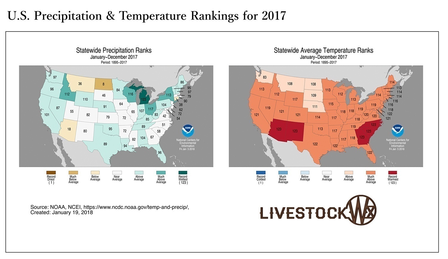
Both Texas and Oklahoma experienced an unusually warm 2017. It was the second warmest year on record for Texas and the 11th warmest for Oklahoma. Texas and Oklahoma also experienced above-average precipitation. Both temperature and precipitation rankings are shown below for the continental U.S.
See Figure 1.
Last year, the U.S. experienced 16 weather and climate disasters each with losses exceeding $1 billion, totaling approximately $306 billion — a new U.S. record. Category 4 Hurricane Harvey, impacting southeast Texas from August 21 – 31, produced extreme rainfall and historic flooding. More than 30 inches of rainfall fell on 6.9 million people, while 1.25 million experienced over 45 inches and 11,000 had over 50 inches. Hurricane Harvey was the costliest U.S. disaster in 2017.
Tragedy also struck in March with the Dumas Complex, Perryton, and Lipscomb County fires, among several others in the southern Plains, which had tremendous impacts to many cattle producers in Oklahoma, Texas and Kansas. Those fires burned over 400,000 acres, resulting in multiple fatalities, and destroying structures and fences with losses of valuable herd genetics from widespread cattle deaths. Further, with the La Nina most likely in place through the winter, we could see conditions favorable for high impact fire weather events in 2018. More on La Niña and wildfire below.
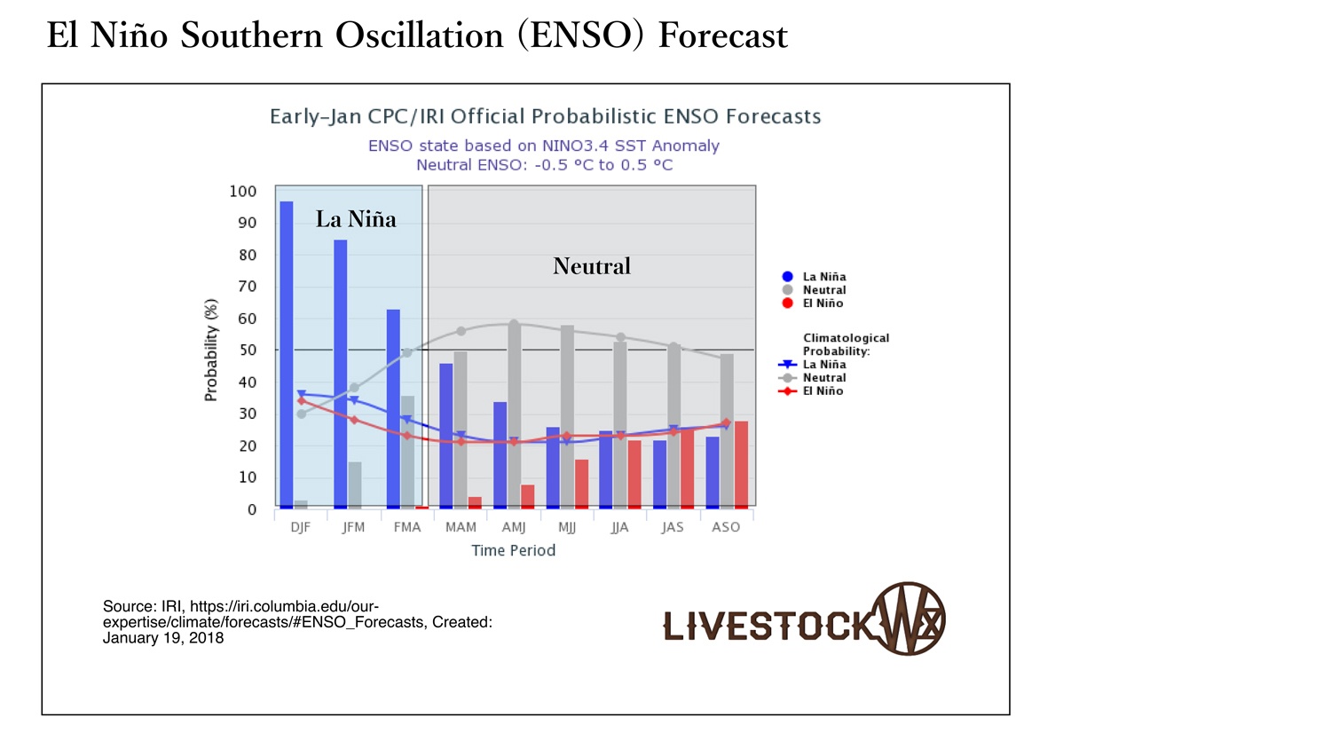
La Niña Development
Perhaps one of the most influential factors affecting U.S. weather this winter has been the weak to moderate La Niña. La Niña is a cooling of equatorial Pacific sea surface temperatures and typically results in dry and warm weather over the southern tier of the nation. The conditions observed since October have been consistent with La Niña throughout much of the region, especially the Southwest U.S., North Texas and Oklahoma, which have been unusually dry and seen the development and expansion of drought.
Most climate models forecast the current La Niña to continue through spring but it should wane (see figure below) and return back to neutral by summer. This is consistent with previous La Niña events as most develop in the fall/winter and usually only last until through the spring.
See Figure 2.
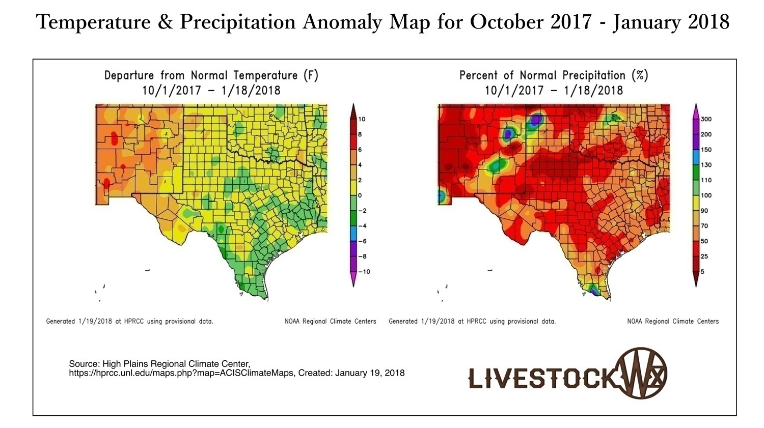
Temperature and Precipitation Since October 2017
Precipitation deficits since October have been running well below normal for most of Texas and Oklahoma (red, figure below) with deficits running 50-25% of normal. On the other hand, temperatures have mostly been around normal to slightly below-normal for Central, East, and South Texas and isolated areas around Oklahoma. Those folks in Central and South Texas have had to dig deep pulling out old jackets and gloves to deal with the arctic air-masses that appeared in December and January.
See Figure 3.
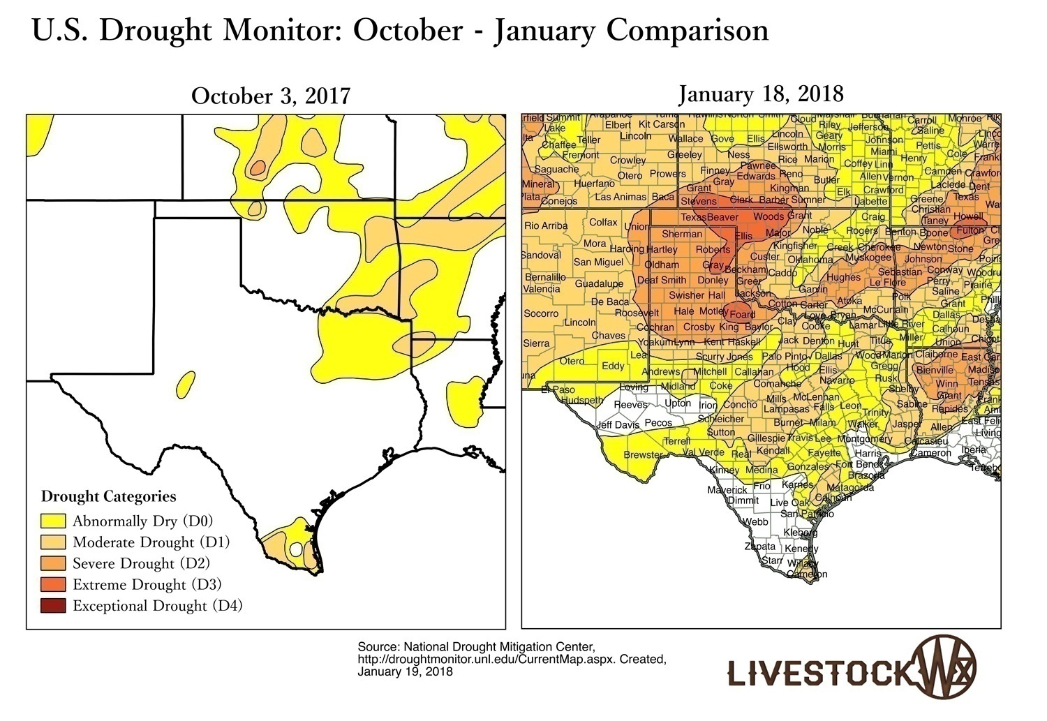
Since October, drought has significantly expanded in areas across Texas and Oklahoma from approximately 2% and 14%, respectively, to currently over 41% for Texas and 84% in Oklahoma. The areas of interest continues to be the Texas-Oklahoma Panhandle, the Rolling Plains of Texas, and western Oklahoma.
See Figure 4.
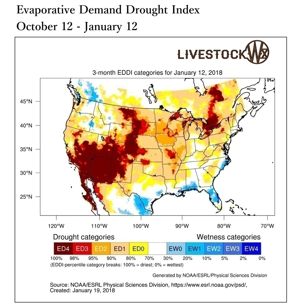
Evaporative Demand
One indicator we are monitoring is a relative new drought index call the Evaporative Demand Drought Index (EDDI, pronounced Eddie). The purpose of the EDDI is to monitor areas experiencing enhanced drying from the atmosphere. Instead of just focusing on precipitation deficits, this index tells us what areas could be experiencing enhanced drying of vegetation and soils. The 12-week EDDI going back to mid October (figure below) shows a trend of enhanced evaporative demand in the Texas and Oklahoma Panhandle and down into the Plains. Given the widespread precipitation deficits in these areas, we will be closely monitoring conditions over the coming months as we move through the spring and into summer.
See Figure 5.
Going Forward: Outlooks From February Through April
Temperature and Precipitation

While the La Niña is expected to wane, it will likely have a significant impact on the weather through the spring. The NOAA outlooks released on January 18, show above-normal temperatures and below-normal precipitation is expected for February through April for the southern tier of the U.S. An interesting situation we are seeing is that some models are showing below-normal precipitation could be favored across the southern Plains into May-July. Forecast skill, though, at lead times of three months or more, are not always accurate, but this potential trend of dry conditions is certainly important to monitor as we transition into spring and summer.
See Figure 6.
Wildfire
According to the Texas Forest Service, the above-normal precipitation over the summer resulted in good grass and other fine fuel growth. Combined with the increase in evaporative demand and expansion of drought over the past three months, and we could see enhanced wildfire initiation through winter and into spring.
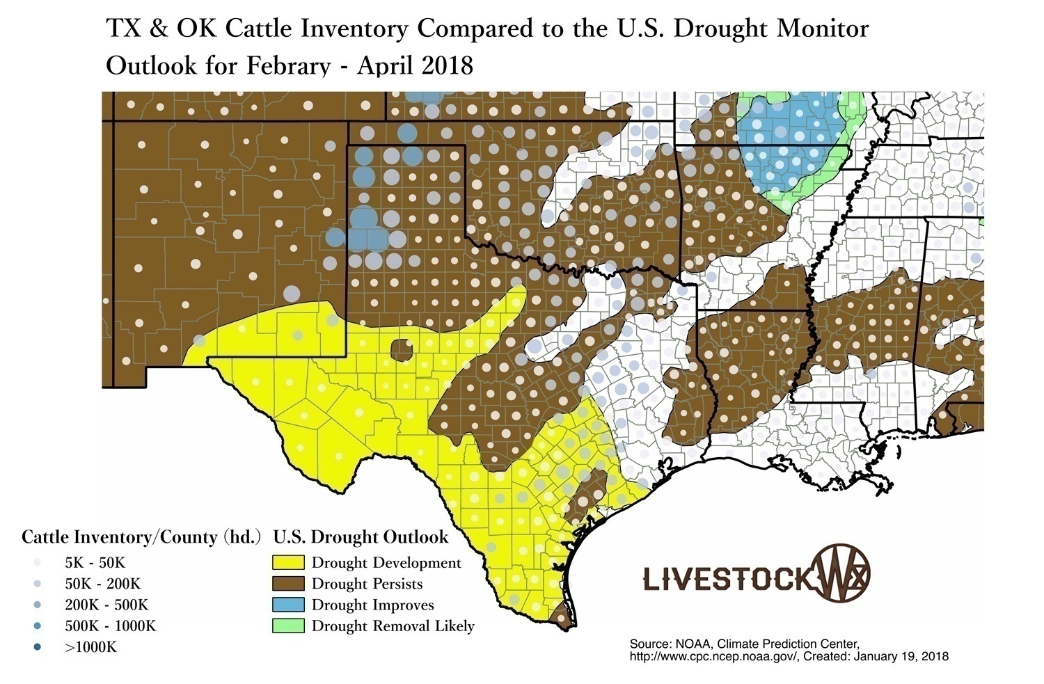
U.S. Drought Outlook
The updated U.S. Drought Outlook for February through April also shows drought development is likely in South, West, and Far West Texas while drought is expected to persist for much of Oklahoma, the Texas and Oklahoma Panhandle and down into Southwest Texas (figure below). Give current conditions and the lack of any signal from the Outlooks makes monitoring your local conditions extremely important. Here at Livestock Wx we will keep our monitoring hats on and will be updating conditions and the forecasts in our weekly article in The Cattleman Update.
See Figure 7.
That’s it for this quarter. If you have any questions about any of the information presented here or would like more specific information that could help your operation or business please contact us at: info@livestockwx.com
The LivestockWX Weather Outlook is featured weekly in The Cattleman Update email newsletter.